---
title: The Submarine Cable Boom as Told by a Decade of TeleGeography Maps
description: Explore over ten years of TeleGeography's submarine cable maps to visualize an evolving undersea network.
image: https://resources.telegeography.com/hubfs/Decade%20of%20maps%20thumbnail.png
---
[](https://www2.telegeography.com/)
- [About](https://www2.telegeography.com/about-us)
- [Research](https://www2.telegeography.com/our-research)
- [Products](https://www2.telegeography.com/products)
- [Solutions](https://www2.telegeography.com/solutions)
- [Resources](https://resources.telegeography.com)
[Log In](https://www.telegeography.com/login/login?service=https%3A%2F%2Fwww.telegeography.com%2Faccount%2Fhome%2Findex)
[Contact](https://www2.telegeography.com/contact-us)
###### Data and Analysis Tools
- [Cloud and WAN Research Service](https://www2.telegeography.com/cloud-and-wan-infrastructure)
- [Data Center Research Service](https://www2.telegeography.com/data-center-research-service)
- [GlobalComms Database](https://www2.telegeography.com/globalcomms-database-service)
- [International Voice Report](https://www2.telegeography.com/telegeography-report-and-database)
- [IP Networks Research Service](https://www2.telegeography.com/ip-networks-research-service)
- [ISP Navigator](https://www2.telegeography.com/isp-navigatorisp-navigator)
- [Transport Networks Research Service](https://www2.telegeography.com/transport-networks)
- [Network Pricing Database](https://www2.telegeography.com/telegeography-pricing-database)
- [WAN Cost Benchmark](https://www2.telegeography.com/wan-cost-benchmark)
- [Product Passes](https://www2.telegeography.com/product-passes)
###### Consulting
- [All Consulting Services](https://www2.telegeography.com/consulting)
- [Submarine Cable Consulting](https://www2.telegeography.com/submarine-cable-consulting)
###### Maps
- [All Map Services](https://www2.telegeography.com/map-services)
- [Sponsor a Map](https://www2.telegeography.com/sponsor-a-map)
- [License Map Data](https://www2.telegeography.com/license-geocoded-map-data)
- [Cite a Map](https://www2.telegeography.com/cite-telegeography-map)
- [Buy a Map](https://shop.telegeography.com/collections/telecom-maps/)
###### Industry
- [Education](https://www2.telegeography.com/telegeography-for-education)
- [Enterprise](https://www2.telegeography.com/enterprise)
- [Tech](https://www2.telegeography.com/tech)
- [Telecom](https://www2.telegeography.com/telecom)
###### Case Studies
- [AI + Retail Telecom Data](https://www2.telegeography.com/where-to-get-global-telecom-data)
- [EXA Infrastructure](https://www2.telegeography.com/exa-infrastructure-case-study)
- [Orange Wholesale](https://www2.telegeography.com/orange-wholesale-case-study)
- [The European Commission](https://www2.telegeography.com/the-european-commissions-data-backed-approach-to-international-policy)
[Back to Resources](https://resources.telegeography.com)
# The Submarine Cable Boom as Told by a Decade of TeleGeography Maps
##### By [Jayne Miller,](https://resources.telegeography.com/author/jayne-miller) Sep 28, 2026
[Maps](https://resources.telegeography.com/tag/maps) [Submarine Cables](https://resources.telegeography.com/tag/submarine-cables)
There's been lots of conversation about the recent boom in submarine cable construction. This flurry of activity becomes clearer when you take a look at how our annual submarine cable map has evolved over time.
Today, we're putting several years' worth of maps back-to-back to visualize an evolving undersea network. (And to reminisce about some of our favorite designs, if I'm being honest.) Give each map a click for a larger interactive view.
### 2013 | An Antique Exploration
[](http://submarine-cable-map-2013.telegeography.com/)
Years ago, our map detailed 232 lit cables and 12 that were anticipated to come online before 2014. [The final design](http://submarine-cable-map-2013.telegeography.com/) charted submarine cable history, chronicling network latency and submarine cable capacity.
### 2014 | Protectors of the Internet
[](http://submarine-cable-map-2014.telegeography.com/)
[In 2014 we depicted 285 cable systems](http://submarine-cable-map-2014.telegeography.com/) that were currently active or due to enter service by 2015, as well as the location of 44 cable laying vessels.
The "Protectors of the Internet" theme incorporated coverage of the companies that actually lay and maintain cables, with detailed information on cable faults and repairs, including the number of breaks and mean time to commence repair by country.
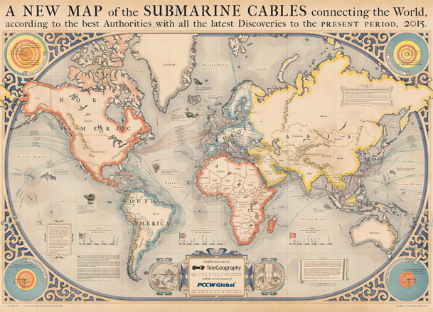
### 2015 | Sub Cables and Sea Monsters
[](http://submarine-cable-map-2015.telegeography.com/)
The next year, we [encountered a few sea monsters](http://submarine-cable-map-2015.telegeography.com/) alongside our annual lineup of submarine cables.
We charted 299 cables that were active, under construction, or would be funded by the end of 2015. (Vox even made a [great undersea cable explainer](https://www.vox.com/2015/3/13/8204655/submarine-cables-internet) using this map!)
### 2016 | 321 Cable Systems Strong
[](http://submarine-cable-map-2016.telegeography.com/)
You could call 2016 our Blue Period.
We like to think of it as the year our map [documented 321 cable systems](http://submarine-cable-map-2016.telegeography.com/). This edition also includes inset maps and infographics that are as data-rich as they are beautiful.
### 2017 | The Adventurer's Map
[](http://submarine-cable-map-2017.telegeography.com/)
We wouldn't blame you if you wanted to play the Indiana Jones theme in the background while you [gaze at our 2017 map](http://submarine-cable-map-2017.telegeography.com/).
This edition borrowed design ideas from your favorite fictional archaeologist, including submarine cable facts as a collection of artifacts, journal entries, and hand-drawn sketches befitting of Indiana Jones.
### 2018 | Detailing 366 Systems
[](http://submarine-cable-map-2018.telegeography.com/)
Our [2018 submarine cable map](http://submarine-cable-map-2018.telegeography.com/?__hstc=45788219.e2dbffab800ecad07d5a59a6b59a32ca.1747323289923.1747323289923.1747323289923.1&__hssc=45788219.1.1747323289923&__hsfp=1535137026) tracks 366 submarine cable systems and 1,006 landing stations that were active, under construction, or expected to be fully funded by the end of 2020. This purple projection has more detail than ever, charting fiber pairs, resiliency, and more.
### 2019 | The Building Boom
[](https://submarine-cable-map-2019.telegeography.com/)
The [2019 edition](https://submarine-cable-map-2019.telegeography.com/) is all about the building boom. Infographics single out the economics of new cables, investors, bandwidth demand, and—of course—a closer look at how content providers get involved.
Unlike previous submarine cable construction booms, companies like Amazon, Google, Facebook, and Microsoft are taking a more active role. These companies have incredible bandwidth demand for their data center traffic, which is driving projects and route prioritization for new cables.
### 2020 | A Rustic Throwback
[](https://submarine-cable-map-2020.telegeography.com/)
Our 2020 edition arrived with a [new interactive experience](https://submarine-cable-map-2020.telegeography.com/) and free map downloads. This traditional, nostalgic design depicts 447 cable systems and 1,194 landing stations that were currently active, under construction, or expected to be fully funded by the end of 2022.
### 2021 | Shout-Out to the Sharks
[](https://submarine-cable-map-2021.telegeography.com/)
Our [2021 Submarine Cable Map](https://submarine-cable-map-2021.telegeography.com/) depicts 464 cables and 1,245 landing stations; 428 cables were active and 36 were planned when we released this candy-colored edition.
There were quite a few new graphics and FAQs to show off. This edition has trivia on cable suppliers, content providers, deployments, fiber, and more.
You'll also find a new shark friend in the top right. You might have heard that sharks are known to bite cables, but bites like this haven't accounted for a single cable fault since 2007. [The majority of damage to submarine cables](https://resources.telegeography.com/what-to-know-about-submarine-cable-breaks) comes from human activity, such as fishing and anchoring.
### 2022 | And It Was All Yellow
[](https://submarine-cable-map-2022.telegeography.com/)
Our [2022 Submarine Cable Map](https://submarine-cable-map-2022.telegeography.com/) got up to 486 cable systems and 1,306 landing stations. It outlined:
- Construction Costs: Despite delays associated with the COVID-19 pandemic, new system spend rebounded in 2020 to $2.7 billion.
- Content Providers Using Capacity: Content providers' international bandwidth growth outpaced that of all other customers. By 2017, content providers had surpassed internet backbone providers as the largest users of international capacity.
- Fiber Pairs: In the Atlantic, rising demand requirements are leading to a substantial increase in the fiber pair count per cable.
### 2023 | Windrose Networks
[](https://submarine-cable-map-2023.telegeography.com/)
What has dashing good looks and depicts 529 cable systems and 1,444 landings? The [2023 Submarine Cable Map](https://submarine-cable-map-2023.telegeography.com/).
Looking closely, you'll find sea monsters, ornate compass roses, and [windrose networks](https://resources.telegeography.com/the-inspiration-behind-this-years-submarine-cable-map-design) woven in. Historically, a windrose network was a crucial navigational aid found on portolan charts and other early nautical schematics used during the medieval age and the Age of Exploration.
### 2024 | A Map Safari
[](https://submarine-cable-map-2024.telegeography.com/)
We added a safari theme to our map repertoire with the [2024 Submarine Cable Map](https://submarine-cable-map-2024.telegeography.com/). This handsome edition explored global connectivity from the sea to the cloud, depicting 559 cable systems and 1,636 landing stations.
At the bottom of the map, you’ll find additional insights on cable construction, cable investments, and cloud infrastructure.
### 2025 | Going Dark

This [futuristic, high-contrast 2025 design](https://submarine-cable-map-2025.telegeography.com/) depicts 597 cable systems and 1,712 landings. For those keeping score, that's 38 more cable systems and 76 more landings than the 2024 edition.
At the bottom of this map, we zero in on *Networks of the Future* with potential capacity, used capacity, and cable deployment stats for six major submarine cable routes: Trans-Pacific, U.S.–Latin America, Trans-Atlantic, Europe–Sub-Saharan Africa, Europe–Asia via Egypt, and Intra-Asia.
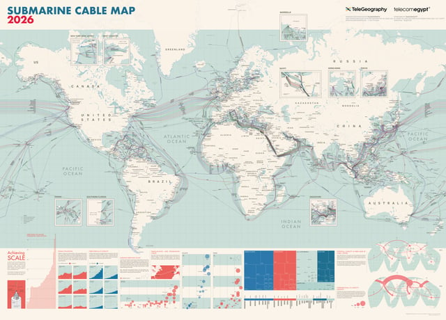
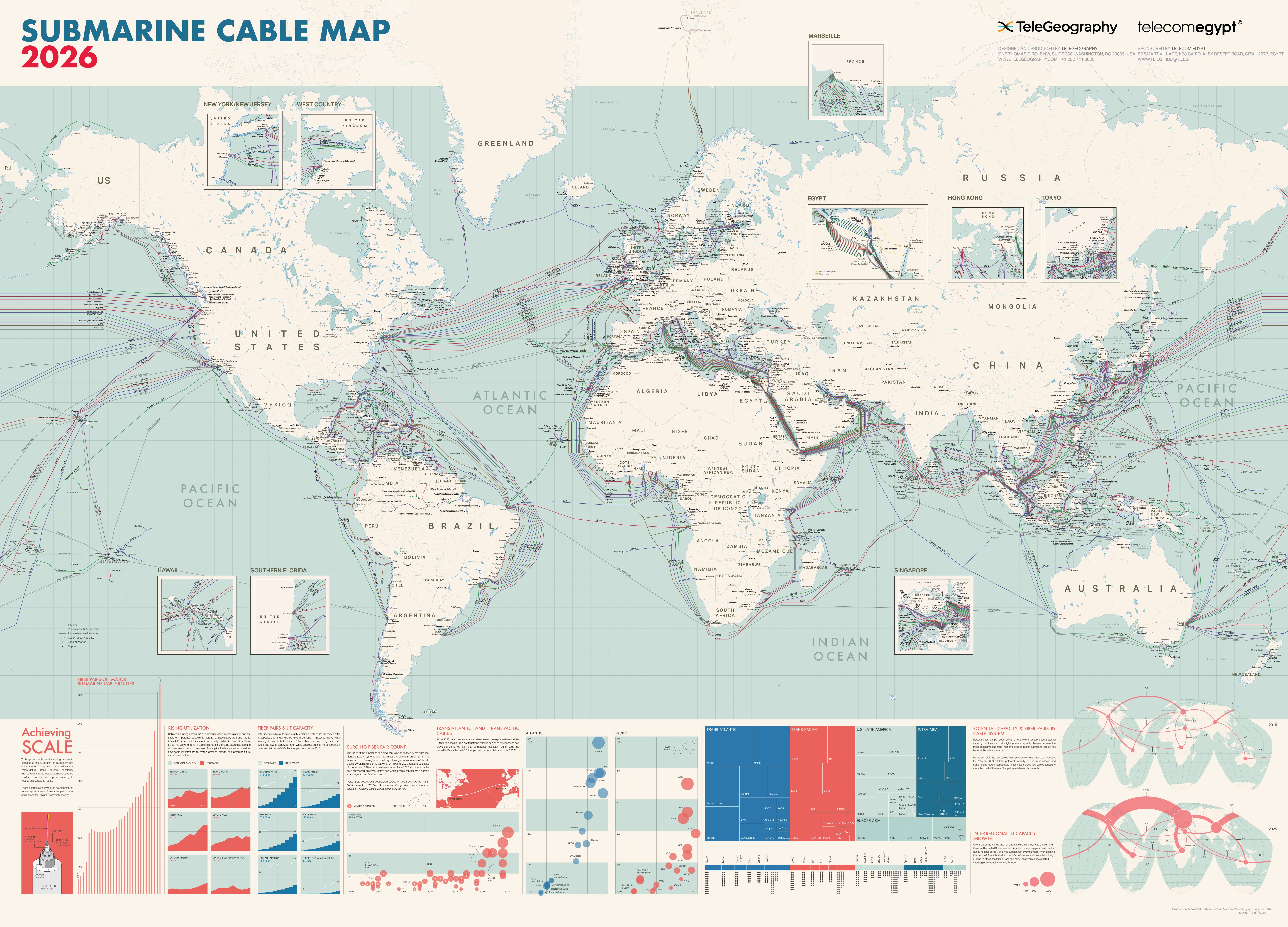
### 2026 | A Retro Look for Today's Cables
[](https://submarine-cable-map-2026.telegeography.com/)
Our [2026 Submarine Cable Map](https://submarine-cable-map-2026.telegeography.com/) is the 30th edition of our iconic annual telecom map, depicting global subsea cable systems through beautiful design. This edition depicts: 694 cable systems, with in-service and planned cables clearly denoted; 1,893 landing stations; ready-for-service date alongside planned cables.
The lower portion of the map illuminates data on the global submarine cable ecosystem:
- Fiber pairs on major routes
- Utilization: lit capacity and potential capacity
- Fiber pairs and lit capacity
- Fiber pairs per system
- Trans-Atlantic and trans-Pacific cable capacity
You can [buy the 2026 submarine cable map here](https://shop.telegeography.com/products/2026-submarine-cable-map).
## Get more submarine cable data
Our **[Transport Networks Research Service](https://www2.telegeography.com/transport-networks)** delivers data and analysis on long-haul networks and the undersea cable market, with forecasts of international bandwidth supply, demand, prices, and revenues. **Learn more and get research samples delivered to your email.**
**[](https://resources.telegeography.com/hs/cta/wi/redirect?encryptedPayload=AVxigLKY6sTkgHIpQNgUMQoV5iNxTD5HICcmnU4ZobNysws887SYTwtX5NNnvfpYE8wX8WyzwQQSFB5eVNvp%2BhrQRQmt2zt1NNA%2BbmUvsXmTp5q0wDfln%2BIuvKDWwLPCByqp6oAsPddCa5UbTTtZ1Q594ih4cth1rXD80VZfDp3MxHlFocGDtgQvBZAGIaLvdmgKOFa2l37tQtdejTnnGDBl3%2FL0irK242U%3D&webInteractiveContentId=211875967255&portalId=594292)**
#### Jayne Miller
Jayne Miller is TeleGeography's Director of Operations. She has over a decade of experience as a writer, editor, and creative strategist.
[View Jayne Miller Work](https://resources.telegeography.com/author/jayne-miller)
## Explore Related Content
###### Blog
Aug 9, 2018
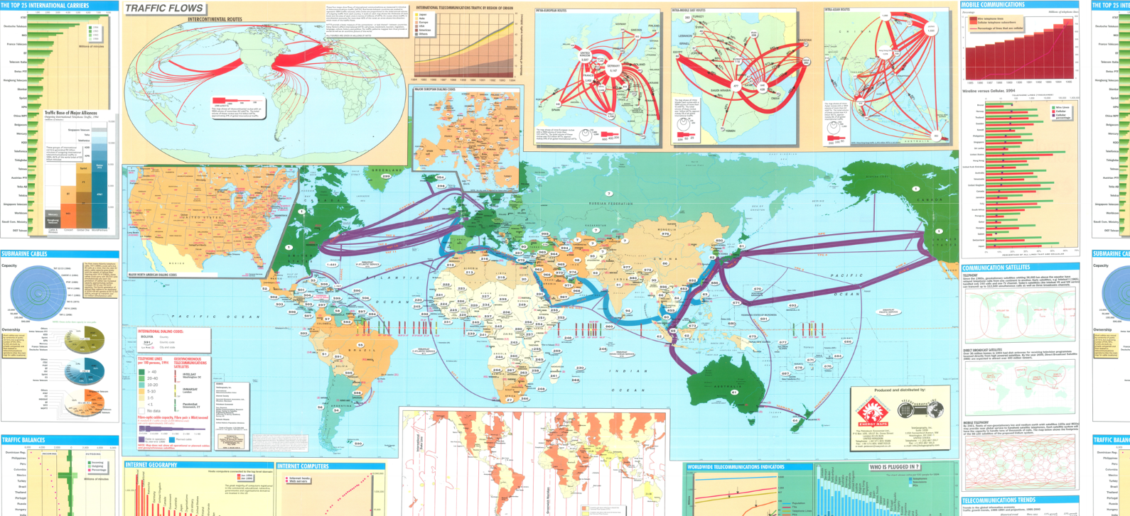
#### [The Ultimate Throwback Thursday: TeleGeography's First Map](https://resources.telegeography.com/the-ultimate-throwback-thursday-telegeographys-first-map-cables-in-1996)
TeleGeography started producing submarine cable maps in 1999, but we had been mapping the world of...
[View More by Jayne Miller](https://resources.telegeography.com/author/jayne-miller)
[Read Full Article](https://resources.telegeography.com/the-ultimate-throwback-thursday-telegeographys-first-map-cables-in-1996)

###### Blog
Apr 24, 2026
#### [Your Go-To Cable Compendium](https://resources.telegeography.com/your-go-to-cable-compendium)
Whether you work directly in telecom or your work overlaps with internet infrastructure in another...
[View More by TeleGeography Staff](https://resources.telegeography.com/author/telegeography-staff)
[Read Full Article](https://resources.telegeography.com/your-go-to-cable-compendium)
###### Blog
Mar 2, 2026
#### [TeleGeography's 2026 Submarine Cable Map](https://resources.telegeography.com/2026-submarine-cable-map)
Happy 30th birthday to TeleGeography's telecommunications map! We're excited to release our 2026...
[View More by TeleGeography Staff](https://resources.telegeography.com/author/telegeography-staff)
[Read Full Article](https://resources.telegeography.com/2026-submarine-cable-map)
[](https://www2.telegeography.com/)
[Login](https://www.telegeography.com/login/login?service=https%3A%2F%2Fwww.telegeography.com%2Faccount%2Fhome%2Findex)
[Contact Us](https://www2.telegeography.com/contact-us)
###### [About](https://www2.telegeography.com/about-us)
- [Research](https://www2.telegeography.com/our-research)
- [Products](https://www2.telegeography.com/products)
- [Solutions](https://www2.telegeography.com/solutions)
- [Demo](https://www2.telegeography.com/demo)
###### [Press](https://www2.telegeography.com/telegeography-press)
- [Events](https://www2.telegeography.com/telecom-events)
- [Careers](https://www2.telegeography.com/careers)
###### [Resources](https://resources.telegeography.com/)
- [Podcast](https://www2.telegeography.com/telegeography-explains-the-internet-podcast)
- [Newsletter](https://www2.telegeography.com/subscribe-to-telegeography-emails)
-
-
All Rights Reserved 2026
- [Privacy Policy](https://www2.telegeography.com/privacy-policy)
```json
{
"@context" : "https://schema.org",
"@type" : "BlogPosting",
"author" : {
"@type" : "Person",
"name" : "Jayne Miller",
"url" : "https://resources.telegeography.com/author/jayne-miller"
},
"dateModified" : "2026-09-29T13:32:43.132Z",
"datePublished" : "2026-09-28T16:00:00.000Z",
"headline" : "The Submarine Cable Boom as Told by a Decade of TeleGeography Maps",
"image" : [ "https://resources.telegeography.com/hubfs/Decade%20of%20maps%20thumbnail.png" ],
"mainEntityOfPage" : {
"@id" : "https://resources.telegeography.com/submarine-cables-over-time-through-the-years",
"@type" : "WebPage"
},
"publisher" : {
"@type" : "Organization",
"logo" : {
"@type" : "ImageObject",
"url" : "https://resources.telegeography.com/hubfs/assets/telegeography/telegeography-logo-blog.png"
},
"name" : "TeleGeography"
}
}
```
```json
{
"@context" : "https://schema.org/",
"@type" : "WebSite",
"image" : "https://www2.telegeography.com/hubfs/Website/assets/logo/telegeography-logo.svg",
"name" : "The Submarine Cable Boom as Told by a Decade of TeleGeography Maps",
"potentialAction" : {
"@type" : "SearchAction",
"query-input" : "required name=search_term_string",
"target" : "{search_term_string}"
},
"url" : "https://resources.telegeography.com/submarine-cables-over-time-through-the-years"
}
```